Public safety and infrastructure management increasingly depend on fast, accurate, and reliable information. As cities expand and critical facilities become more complex, traditional monitoring methods often face limitations in coverage, response speed, and operational efficiency. Advanced aerial technologies are changing how organizations collect and analyze information by combining drones, artificial intelligence, and intelligent data processing.
Icecypress Technology, a spatial intelligence AI company specializing in 3D and AI technologies, develops intelligent solutions that strengthen situational awareness and decision-making capabilities. Its BeeSmart Drone Swarm solution integrates onboard AI, multi-drone collaboration, and large-scale mapping capabilities to create an intelligent surveillance and reconnaissance platform. The system supports both civilian and professional applications by enabling real-time perception, processing, and response without depending on traditional ground infrastructure.
The Growing Role of an Aerial Surveillance System in Modern Operations
An aerial surveillance system provides organizations with a flexible way to monitor large areas, collect critical information, and improve operational visibility. Compared with conventional monitoring approaches, aerial platforms can access challenging environments, cover wider regions, and deliver updated information more efficiently.
Public safety departments, infrastructure operators, and emergency response teams require accurate data to manage complex situations. Whether monitoring transportation networks, inspecting large facilities, or supporting emergency operations, aerial intelligence helps organizations understand conditions from a broader perspective.
Modern aerial solutions are moving beyond simple image collection. By combining AI-powered analysis with autonomous flight capabilities, advanced systems can identify important details, process information quickly, and provide valuable insights for decision-makers. This transition allows aerial platforms to become intelligent tools rather than only remote observation devices.
Drone Surveillance System Enables Real-Time Intelligence Processing
A traditional drone often focuses on capturing images or videos and transferring data back to a central location for analysis. However, this approach may create delays when immediate decisions are required, especially in remote or rapidly changing environments.
A modern drone surveillance system equipped with onboard intelligence can process information directly during missions. Icecypress Technology’s BeeSmart Drone Swarm is designed around intelligent perception, autonomous processing, and collaborative operations. The system can identify targets, generate maps, and deliver actionable intelligence in real time.
By reducing dependence on external processing infrastructure, the solution supports faster responses and more efficient operations. This capability is valuable for scenarios where communication conditions are limited or where immediate situational awareness is essential.
Multi-Drone Collaboration Creates a More Efficient Aerial Network
Large-scale monitoring tasks often require broader coverage and continuous information collection. A single drone may have limitations in flight time, coverage area, and operational flexibility. Multi-drone collaboration provides a new approach by allowing multiple aerial units to work together as an integrated network.
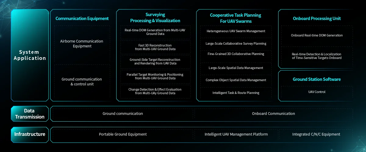
BeeSmart Drone Swarm uses a multi-drone system architecture built around onboard intelligent units, collaborative drone networks, and portable ground terminals. This structure enables air-ground collaboration and centerless ad-hoc networking, allowing multiple drones to coordinate missions without relying on fixed infrastructure.
Through collaborative operation, multiple drones can complete complex tasks more efficiently. They can support large-area mapping, surveillance missions, and information gathering while maintaining continuous communication and coordination throughout the operation.
AI-Powered Aerial Mapping Improves Infrastructure Management
Infrastructure systems such as roads, bridges, energy facilities, and industrial sites require regular monitoring to maintain safety and reliability. Manual inspections can be time-consuming, expensive, and difficult in hazardous locations.
AI-enhanced aerial mapping provides infrastructure managers with detailed visual information and accurate spatial data. By collecting information from the air and processing it intelligently, organizations can better understand structural conditions, identify potential issues, and improve maintenance planning.
Icecypress Technology combines spatial intelligence capabilities with drone-based data collection to support more efficient mapping and monitoring workflows. Its solutions help transform aerial data into practical insights, enabling organizations to manage infrastructure assets with greater accuracy and efficiency.
Independent Operations Reduce Dependence on External Infrastructure
Many surveillance and mapping missions take place in environments where traditional communication or support systems may not be available. Relying heavily on ground stations can limit operational flexibility and slow down response times.
An intelligent surveillance and reconnaissance platform addresses this challenge by creating a complete operational loop from mission planning to data output. BeeSmart Drone Swarm combines onboard AI processing, drone collaboration, and portable ground terminals to support independent mission execution.
This infrastructure-independent design allows the system to operate in complex environments while maintaining real-time data processing capabilities. For public safety and infrastructure applications, this means faster deployment, enhanced adaptability, and stronger operational resilience.
Supporting Safer and Smarter Decision-Making Through Aerial Intelligence
The combination of artificial intelligence, drone technology, and spatial computing is reshaping the future of monitoring and management. Organizations are increasingly seeking solutions that not only collect information but also analyze data and support immediate decisions.
Icecypress Technology’s BeeSmart Drone Swarm demonstrates how aerial intelligence can provide a complete solution for surveillance, reconnaissance, and large-scale mapping. By integrating AI processing with collaborative drone operations, the platform helps users achieve more accurate monitoring and faster responses.
As demand grows for smarter public safety systems and more efficient infrastructure management, intelligent aerial solutions will continue to play an important role. Through advanced aerial surveillance system technologies and drone surveillance system capabilities, organizations can build stronger awareness, improve operational efficiency, and make better-informed decisions in complex environments.
